Sunday, August 22, 2021

Donner - Notess from Mullen Book

Donner Trail (pages refer to Mullen Book)

4/15

Springfield Illinois (see marker)

5/12

Independence Missouri

5/15

Blue River, Heart Grove, 22 miles west of independence

5/17

Wakarusa River, 60 miles west of Independence

5/19

KAW (Kansas) River Kansas, state park

5/22

Camp at Soldier Creek in Kansas,  Camp at Black Paint creek, 116 miles from Independence Missouri

5/24

*Big Blue Earth River, 3/4 of mile from spring at Alcove Spring, where reed carved is initials

5/16

*Vermillion Creek; 163 miles from Independence Missouri

5/29

Sarah Keyes dies, buried in banks of Big Blue River on right side of Oregon California trail, grave unknown

5/31

Cross the Big Blue River


Camped on Little Blue River


88 miles from Big Blue River Crossing, 251 miles from Independence

6/9

Along PLATTE River


Bluffs overlooking PLATTE river

6/14

Young boy dies after being run over by the wagon


Foreign and 50 miles from independence, 200 miles to Fort Laramie


Dash hollow camp, beyond south PLATTE river


*Castle rock near North PLATTE river in Nebraska

6/23

*Chimney Rock, BAYNARD, Nebraska

`6/26

Passed Scott’s Bluff, camp near Fort Bernard on PLATTE river; *Scotts Bluff National Park, near Fort Barnard on Platte river, camped at Fremont Spring


*Fort Laramie, Reed learns of Hastings cut off

6/30

*Camped near spring within sight of Laramie peak, 32 miles from Fort Laramie, see page 87 for camps

7/4

Camp at LA PRELE creek in WY

7/6

Camped by a natural bridge across North Platte River


*Continental divide at South Pass


Camp at Willow Springs, two days after leaving North Platte River


*Letter received from Hastings; *Three days from Independence Rock, crossed Platte River

7/12

*Independence Rock, Overland Trail, slept near bass, 100 miles to Southpass


*Devils Gate (see page 95)  can be seen from Independence Rock,


Sweetwater River

7/17

*Summit of South Pass, 920 miles from Independence Missouri

7/24

Camped on little Sandy River, one of the forks of the Green River, a tributary of the Colorado river


*Cut off near little Sandy River (see page 101), Road to left to Fort Bridger, Road to write to Fort Hall,


Camped at Big Sandy River, 20 miles from turning left,


George Donner in charge,


Cross Green River

7/26

*Camped in meadow 1/2 mile from Fort Bridger

8/2

camp at Bear River, Snow capped mountains nearby, Echo Canyon Camp

8/4

Snyder joins with Graves family

8/9

Weber Canyon Path, headed west toward WASATCH mountains, crossed Yellow Creek near Wyoming and Utah border, camp at HENIFER Utah, Wasatch Mountains, camp at Dixie Hollow River, check out East Cannon State Park nearby

8/12

Hogsback Summit, after giving up on Weber canyon, Big mountain, East Canyon Creek; mouth of little Emigrant Canyon, Dixie Hollows to Emigrant Canyon on route 65 21.9 miles

8/16

Graves family joins party with Snyder in tow, on a party now consist of 87 people +22 wagons

8/18

cut through Reed’s gap, Big mountain into Mountain Dell Canyon

8/21

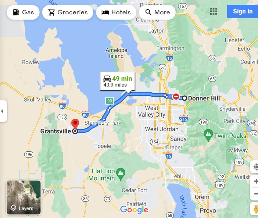
Donner Hill see historical marker, see Internet for coordinates

8/25

pass through Grantsville today, see Donne-Reed museum in town, pass-through Hope Wells Utah where a note from Hastings was found, IOSEPA is this the same as Hopewells?

8/30

trek across the great Salt Lake desert begins;  come close to Pilot Peak along the way

9/1

look for a marker at Silver Island and Spring at base of Pilot Peak

9/4

spring at base of mountain named after Donner party, Donner spring is 5.9 miles to Pilot Peak, (turn right off 80 at Indian Lunch Buffet and Café)

9/11

make way across Silver Zone Pass to Big Springs, 3 miles from Donner Spring, Johnson’s ranch and Big Springs

9/13

Flowery Springs camp, Jaspur Pass

9/15

14 miles over PEQUOP Mountain via Jaspur pass, Mound Springs across Spruce Mountains what is now Clover Valley, see Mound Springs coordinates on Web, 216 miles from Pilot Peak to Mound Springs

9/18

Ruby Valley, Thompson Creek, 50 Springs

9/20

in Ruby Valley, Davis Ranch, Cave Creek, see google map, near South Ruby Lake Camp off Ruby Valley Road, party went around the southern end of the Ruby Mountains, route up Mineral Valley, last camp in Ruby Valley

9/22

across crossed west via Overland Pass, reached Huntington Creek, Huntington Valley, camped at Sadler Ranch, Sinking Creek Valley

9/25

crossing Huntington Valley, follow Huntington Creek into Canyon, South Fork Canon (where I stayed?), Camp is where Smith in Huntington Creeks met,

9/27

came out of Canyon and hit Humboldt River , CARLIN, MOLEEN, exit in Canyon at Susie Creek, the “short trip” ends, Moleen to Elko 12 miles, Moleen to Carlin 15 miles, Carlin to Golconda 87 miles

9/29

BEOWAWE, joined by two Indians one called “Thursday” (like Donner): Gravelly Ford nearby

10/2

camped midway between Battle Mountain and Stone House, note: South Fork to Golconda 127, miles

10/4

Red house

10/5

Snyder killed

10/6

near Ironpoint, the Donners are two days ahead on trail

10/9

IMLAY, 49 miles from Golcconda, WINNEMUCCA is 34 miles from IMLAY, IMLAY to Truckee is 167 miles

10/11

Lovelock on route 80, Breens horse dies as a result of Eddy not helping him get out of the mud

10/13

begin hike over northern 40 Mile Desert to Truckee River

10/16

camp death, Wadsworth is north of 80, Wolfinger is killed by Spitzer in Reinhart, Begin walk up winding Truckee River, Truckee River crosses route 80 here

10/20

Donner Springs in Reno, Donner park located at 4385 LORETO Ln. in Reno, lead wagons reach Truckee Meadows ( Reno today), LAGOMARSINO Canyn near Lockwood, 10 miles to Reno

10/23

Pike killed in Truckee Meadow by accident

10/25

emigrants climb to Sierra, Donner’s are the last to leave the Meadows, the Donner trail is believed to be between Big Valley and HOKE Valley, Stampede and Prosser reservoirs

10/27

Donner brakes axle, George cuts hand, a storm is brewing

10/30

group arrives in valley east of Donner Lake

11/3

first attempt at Summit, snow

11/4

snow drifts to 10 feet deep

11/5

Pioneers take shelter


"On the Trail of the Donner Party " with the Wonder Hussy

In searching the web for a good itinerary for travelling the Donner Parry Trail today, I came across this wonderful seven-part YouTube series by a delightful travel  enthusiastic named “Wonder Hussy.”  You can join me on Donner’s and my trip by following her series, since she did her research well and hit all the highlights of that hapless Dinner (I mean, Donner) arty journey 175 years ago.


Following the Trail of the Donner Party, Part 1 of 7: the Adventure Begins


Following the Trail of the Donner Party, Part 2 of 7: Crossing the Plains


Following the Trail of the Donner Party Part 3 of 7: The Rockies


Following the Trail of the Donner Party Part 4 of 7: The Hastings Cutoff


Following the Trail of the Donner Party Part 5 of 7: Crossing the Great Basin Desert


Following the Trail of the Donner Party, Part 6 of 7: the Sierra Mountains


Following the Trail of the Donner Party, Part 7 of 7: Snowbound

Friday, August 20, 2021

Note to anyone following this blog

You will see a lot of things you do not recognize as my usual propound posts.  That’s because the OTR-11 has not yet started. What you see are scraps of notes that I may wish to access on my blog while I am on the journey. Right now, I am going through the 379-page Mullen book (The Donner Party Chronicles) page by page, and Donner day by Donner day, extracting information on sites to visit, routes to take, camps to pitch my tent in, etc. I am quickly coming to the conclusion that with the 11 days I have allow voted to get from Springfield IL top Donner Lake, there is no way that I can stop at every Donner site, considering it took the hapless Donner party from April 15th to November 3rd (202 days) to make that same journey.  So, I will plan the route I take by sites I need to stop at, and as I drive along the roads and trials, imagine what took place along that route 175 years ago.


donner --- pilot peak to clover valley

donner iospen to pilot peak

donner hill to Grantsville

Donner Hill outside salt lake city


Wednesday, August 18, 2021

RIP John Snyder

As with most of my trips, I plan very few things in advance.  Most of the time I plan an ultimate outward-bound destination (e.g., Arctic Ocean), but sometimes I do not (Labrador, for instance, was only added as my ultimate destination on my 2002 trip when I was a stone’s throw away in Newfoundland, after reading the “Call of the Labrador Wild” en route). I usually plan the outward-bound route in general, but reserve the right to change it or deviate from it as I go along.  I never plan the inward-bound journey until I point the Defender east. Some of the best destinations I picked up along the way from locals or others I met along the way.  This year, so far, I only have two camps as destinations (in Lake Tahoe and Samuel Taylor north of San Francisco), as well as the route starting in Springfield, Illinois, i.e., the hapless Donner Party trail.  Although I intend to follow that route as closely as I can, one site in particular I hope to visit is the place where the hapless teamster John Snyder met his end at the hands of James Reed, one of the Party’s leaders.  I will let you read a synopsis of poor John’s story (see #1 below) and a research paper (see #2 below) prepared in 2012 about where his grave Is located. Who knows I may even try to drive the Defender up that hill that caused the brouhaha between John and fellow teamster  Milt Elliot .


If you read these two pieces, who do you think was to blame for John’s demise, him or Reed?


1- John Snyder (unknown-1846) - Find A Grave Memorial


2- OJ-JohnSnyderGrave-Fall2012.pdf (hhrdd.org)

Tuesday, August 17, 2021

A journey of 7000 miles begins with one step

Okay, I took the first steps towards OTR-11 today.  I made reservations for Lake Tahoe for September 27-30th a camp in Lake Tahoe where Erde and I stayed in 2014, just after Leben died.  That was the camp where we were visited by a grizzly during the night, as he (or she) tried to get up on my roof to get at my food containers.  We will stay there for a few days and then travel on to a wonderful camp north of San Francisco in a stately red oak  forest where we will stay for two nights before moving on somewhere.  My guess is that I will head back home by way of route 50, bivouacking in some wonderful desert camps in Nevada and Utah along the way, before getting on route 70 to take us back home.


Why Lake Tahoe?  Well, it is the closet camp with sites available near Donner Lake.  My plan is to take my usual route from DC to Springfield Illinois, and then hop onto the Donner Party Trail, all the way to Donner Lake in Truckee California.  While it took that hapless group of pioneers eight months to make the journey from Springfield, I hope to make it in five days, maybe seven .Or maybe four months if my 2016 luck comes back to haunt me.


1. Springfield, Illinois
April 16, 1846
The starting point for the Donner Party including the Reed family and the Donner family.  The party was comprised of 32 members including the Reed's 2 servants and 7 teamsters who drove the wagons.  

2. Independence, Missouri
May 10 - May 12, 1846
In May 1846, the nine covered wagons made the slow journey from Springfield, Illinois to Independence, Missouri.  The Donner Party would purchase provisions here for their long, arduous journey to California.  

3. Fort Laramie, Wyoming
July 3 - July 5, 1846
During a conversation at Fort Laramie with mountain man James Clyman, James Reed is urged "to go the old route."  Reed disregards Clyman's advice and makes the fateful decision to take Hastings Cutoff.  

4. Little Sandy River, Wyoming
July 18, 1846
The parting of ways.  As the bulk of the Springfield, Illinois entourage turned right toward the familiar route, twenty wagons, including the ones belonging to the Donners and the Reeds, turned left toward Fort Bridger and the entrance to Hastings Cutoff.  

5. Fort Bridger, Wyoming
July 24 - July 31, 1846
Expecting to be greeted by Lansford Hastings who would lead them through Hastings Cutoff, the Donner Party arrives at Fort Bridger only to find instructions left by Hastings who had left a week earlier with another team of emigrants heading for California.

6. Echo Canyon, Utah
August 4 - August 5, 1846
After a week of steady progress on the new trail outlined by Hastings, the Donner Party found a note at the bottom of Echo Canyon from Hastings.  According to the note, the road up from the canyon was impassable and he advised them to wait until he could find a better route.  When James Reed found Hastings, he refused to join the party and told Reed to lead the party through the canyon and up Big Mountain.  

7. Great Salt Lake Desert, Utah
August 30 - September 3, 1846
The 87 members of the Donner party began their treacherous trek across the Great Salt Lake Desert.  There they encountered conditions they'd never imagined: by day, searing heat that turned the sand into bubbling stew that swallowed their wagons, and at night, frigid winds that blew sand, suffocating their oxen.  Five days and eighty miles later, they stumbled out of the Salt Desert filled with anguish and dismay.  

8. Humboldt River, Nevada
October 2 - October 15, 1846
The murder of John Snyder, a driver for the Graves family, occurs at the hands of James Reed.  While the majority of the party deems the murder punishable by hanging, Reed's wife, Margaret, begs for his life.  Reed is instead banished from the party. 

9. Donner Lake. Jacob Donner’s wagon wheel broke down just before Truckee Lake, now called Donner Lake. The rest of the party moved on to wait for him at Truckee Lake.  As fate would have it, it snowed that night, and it snowed, and it snowed.  The pass over the Sierra Nevada the next day was impassable, and the rest of the story is history.

10. Sutter's Fort, California
By September, all of the emigrants of 1846 had safely arrived at Sutter's Fort in California.  All except the Donner party, that is.  In late October, the newly arrived emigrants were shocked to see James Reed emerge from the wilderness to tell the unfortunate tale of his fellow travelers.  John Sutter gave Reed horses and supplies to bring back to his starving family and others.  Relentlessly bad weather forced Reed to abandon his hopes of making a rescue for four long months.  

.

Sunday, August 1, 2021

Grave of Sarah Keyes Alcove Springs


The Grave of Sarah Keyes on the Oregon Trail

by William E. Smith

May 1936 (Vol. 5, No. 2), pages 208 to 212
Transcribed by Elizabeth Lawrence; digitized with permission of
the Kansas Historical Society.

IN APRIL, 1830, more than 100 years ago, the first wagons passed over the Oregon trail.[1] Sixteen years later the ill-starred Donner party toiled along the trail across Kansas, to meet disaster in the winter snows of the Sierra Nevada mountains. Here forty-two of the ninety died from starvation and cold, and a portion of the remainder barely kept alive by subsisting on human flesh.[2]

The parties composing this caravan left Independence, Mo., about May 1, 1846. A short distance out of Independence it consisted of the following: Sixty-three wagons; one hundred nineteen men; fifty-nine women; one hundred ten children; bread stuffs, 58,484 lbs.; bacon, 38,080 lbs.; powder, 1,065 lbs.; lead, 2,557 lbs.; guns, 144; pistols, 94; 700 head of cattle and 150 head of horses. This was an unusually large caravan and later divided itself into two or three trains.[3]

After crossing the Kansas river the company was increased by two. A Mrs. Hall, the wife of one of the immigrants, gave birth to twins. On the morning of May 19, a new census of the party was taken and it was found to consist of ninety-eight fighting men, fifty women, forty-six wagons, and 350 head of cattle. Two divisions were made for convenience of marching. On this day nine wagons from Illinois belonging to Messrs. Reed and Donner and their families joined.

The caravan moved slowly, seldom more than fifteen miles per day, and on May 26, 1846, the band of immigrants reached the Big Blue in what is now Marshall county, at what is called Independence crossing. The river was very much swollen and they were forced to remain at this camp from May 26 until nine o'clock p.m. on the 31st, when the wagons, oxen and horses were safely landed on the west bank. Because of the continued high water a crude ferry boat, named Blue River Rover was constructed by making dugouts of large cottonwood trees. Two of these dugouts were framed together so that the wheels of the wagons rested in the canoes. Lines were attached to both ends and the raft was pulled back and forth by hand.

While the emigrants were waiting to cross the river they were saddened by the death of Sarah Keyes, whose grave as it is today is described in this paper. Their activities of these few days are well depicted by Edwin Bryant in his Rocky Mountain Adventures, on which this article is principally based.

On the 26th the women washed clothes and some of the men fished, one catch being a catfish three feet long. There had been some contention among the leaders of the caravan, and the evening of that day was given over to a public meeting in an effort to prepare a system of law for the purpose of preserving order. The day had been delightful, nothing disagreeable had happened, perfect harmony prevailed. After sunset a new moon appeared above the tree tops to the west of the camp, but later, however, a terrific thunder storm and heavy rain came up. Of this, Mr. Bryant says:

A terrific thunder storm roared and raged, and poured out its floods of water throughout a great portion of the night. But for the protection against the violence of the wind, afforded by the bluffs on one side and the timber on the other, our tents would have been swept away by the storm. The whole arch of the heavens for a time was wrapped in a sheet of flame, and the almost deafening crashes of thunder, following each other with scarcely an intermission between, seemed as if they would rend the solid earth, or topple it from its axis. A more sublime and awful meteoric display, I never witnessed or could conceive.

The morning of the 27th was clear, cloudless and peaceful, just as we have seen it many times in Kansas after a thunderstorm. The rain caused the river to rise several feet. Mr. Grayson, who was a member of the party, and others went out to search for bee trees and they returned with several baskets of honey.

It was on the morning of May 29, 1846, when Mrs. Keyes died. Mr. Bryant says:

Last night Mrs. Sarah Keyes, a lady aged seventy, a member of the family of Mr. J. H. Reed, of Illinois, and his mother-in-law, died. Mr. Reed, with his family, is emigrating to California. The deceased Mrs. Keyes, however, did not intend to accompany him farther than Fort Hall, where she expected to meet her son who emigrated to Oregon two or three years since. Her health, from disease and the debility of age, was so feeble, that when she left her home she entertained but faint hopes of being able to endure the hardships of the journey. Her physicians had announced to her that she could live but a short time, and this time she determined to devote to an effort to see her only son once more on earth. Such is a mother's affection! The effort, however, was vain. She expired without seeing her child.

The event. . . cast a shade of gloom over our whole encampment. . . All recreations were suspended, out of respect for the dead, and to make preparations for the funeral. A cottonwood tree was felled, and the trunk of it split into planks, which being first hewn with an axe and then planed, were constructed into a coffin, in which the remains of the deceased were deposited. A grave was excavated a short distance from the camp, under an oak tree on the right hand side of the trail. A stone was procured, the surface of which being smoothed, it was fashioned into the shape of a tombstone, and the name and age, and the date of the death of the deceased were graved upon it.

At 2 o'clock P.M., a funeral procession was formed, in which nearly every man, woman and child of the company united, and the corpse of the deceased lady was conveyed to its last resting place in this desolate but beautiful wilderness. Her coffin was lowered into the grave. A prayer was offered to the Throne of Grace by the Rev. Mr. Cornwall. An appropriate hymn was sung by the congregation with much pathos and expression. A funeral discourse was then pronounced by the officiating clergyman, and the services were concluded by another hymn and a benediction. The grave was then closed and carefully sodded with the green turf of the prairie, from whence annually will spring and bloom its brilliant and many-colored flowers. The inscription on the tombstone, and on the tree beneath which is the grave, is as follows: "Mrs. Sarah Keyes, Died May 29, 1846; Aged 70."

The night is perfectly calm. The crescent moon sheds her pale rays over the dim landscape; the whippoorwill is chanting its lamentations in the neighboring grove; the low and mournful hooting of the owl is heard at a far off distance, and altogether the scene, with its adjuncts around us, is one of peace, beauty and enjoyment.

Mr. Bryant described the Blue at Independence crossing as a stream about one hundred yards wide, with turbid water and strong and rapid current. When he saw it it was in flood time. He mentions a small spring branch which empties into the Blue just above the ford. He followed up this small branch, he says, about three quarters of a mile from the camp, where he found a spring of water, ice-cold and pure. From the shelving rock projecting over a basin a beautiful cascade of water fell some ten or twelve feet. This spring was named by them, "Alcove Spring," and many names were graven on the rocks, and on the trunks of trees surrounding it.

On March 16, 1930, the writer visited Independence crossing. The river was normal and the crossing was about fifty yards wide, with a gravelly bottom on the east side. Numerous floods had left a high bank on the west side. I am informed that this crossing was used a great deal up to the flood of 1903. The small stream emptying into the river just above the ford is still there, although at the time I visited it, it was dry. I followed the little creek up to Alcove Springs, which is about one half mile from the crossing, practically due east. No doubt the spring has changed considerably since Mr. Bryant saw it in 1846. No water was running over the ledge. The stones upon which the names were graven had broken from the ledge and had been washed down the stream a short distance. There were two very fine springs coming out of the ground on the east side. The following names and dates were engraved upon the rocks:

ALCOVE SPRING

Engraved by Edwin Bryant

May 28, 1846

J. F. REED

May 26, 1846

The small stream is called Alcove Springs creek. The grave of Sarah Keyes is between Alcove Springs and the crossing, as nearly as I can judge, about half way or a quarter of a mile from the springs and a quarter of a mile from the crossing. It is located on a sloping hill on the north side of Alcove Springs creek, about fifty yards from the wagon road. It is on the side of the bluffs and this ground is still virgin prairie, used for pasture. The grave is beside an oak tree, which now consists of three trees growing from the same stump. They are not very large, being about one foot in diameter in the largest place, although the stump from which they sprang is about two and one half to three feet thick. Apparently the parent tree was blown or cut down and these sprouts came up from the stump and grew together at the base and formed three trees. The stone which was fashioned into a headstone is still standing, the upper portion rounding. Apparently all markings are obliterated; neither did I find any markings on the tree as described by Bryant. This, however, is not strange, as eighty-four years had passed and the markings would have long since been grown over.

Independence crossing, the grave, and Alcove Springs are all in the southeast quarter of section thirty-one, Elm Creek township, in Marshall county. They may be easily reached by automobile, by driving to Blue Rapids, taking the Marysville road from there, and after crossing the Big Blue, taking the first road to the left and driving up the river to within two miles of Shroyer. This wagon road passes very close to the crossing and one can drive into the pasture, by the grave, and up to Alcove Springs.

One can only hazard a guess why this was called Independence crossing. Presumably it was named for Independence, Mo., where those traveling on the Oregon trail in the early days outfitted themselves for the journey across the plains. The Donner party named Alcove Springs. The early writers on the Donner party often referred to this grave as being near Manhattan, and in the Kansas City (Mo.) Star of Wednesday, June 11, 1930, in an article, "Death Takes the Last Survivor of the Donner Party," the following appears: "On May 29, Grandmother Keyes died and she was buried under a big oak tree where was later the city cemetery of Manhattan."

This of course is not true, as this grave is located about eight miles south of Marysville and about fifty-two miles north of Manhattan.